

Climbing the highest peak in California and in the contiguous US was quite the adventure! Not only did we climb Mount Whitney, but we traveled through Death Valley National Park and Badwater Basin (the lowest point in the US) to get there which made for a pretty cool way to mark this off the list. Almost 14,800′ of gain in less than 24 hours. This trip is one I most definitely reccomend, but there are some things you should know before you climb.

PERMITS:
Whether you aim to climb Mount Whitney in a single day, or backpack in and camp, Whitney is a permitted climb no matter which route you take. They have a lottery system in place for permits at Recreation.gov that opens Febuary 1. According to the Inyo National Forest site, only 34% of applicants were awarded their requested dates in 2019. Each year more and more people apply, lowering the chances of success. Once permits have been awarded March 24, remaining applicants do get first dibs at whatever dates are leftover on April 1. Web sales open May 1 and people have been lucky to occasionally find something that is left, but they typically go incredibly fast.
BEST TIME TO CLIMB:
Mount Whitney is located in southern California. Depending on whether it is a La Nina vs El Nino winter can actually help determine how much potential snow Whitney can hold in a given year. I summited June 10th which typically would warrant early season conditions with plenty of snow, but with a record dry year, and high heat, our route was virtually snow free. Heavy El Nino years can mean there is snow at Trail Camp and up the cirque of the 99 switchbacks well into August. When you apply in Febuary, take a look at snow water reports for California, as well as future forecasts for the remainder of spring to give you a guestimate of what the summer may look like as you plan your climb. Typically the later in the summer you go, the better your chances are at a snow free route. However, the later into summer you go you also risk monsoon season and will be racing weather on your climb. Always check weather and conditions before you go. Bring microspikes (and possibly an ice axe) if there is still snow, and always watch the clouds as you do not want to be on the high mountain in a thunderstorm.
THE ADVENTURE BEGINS!
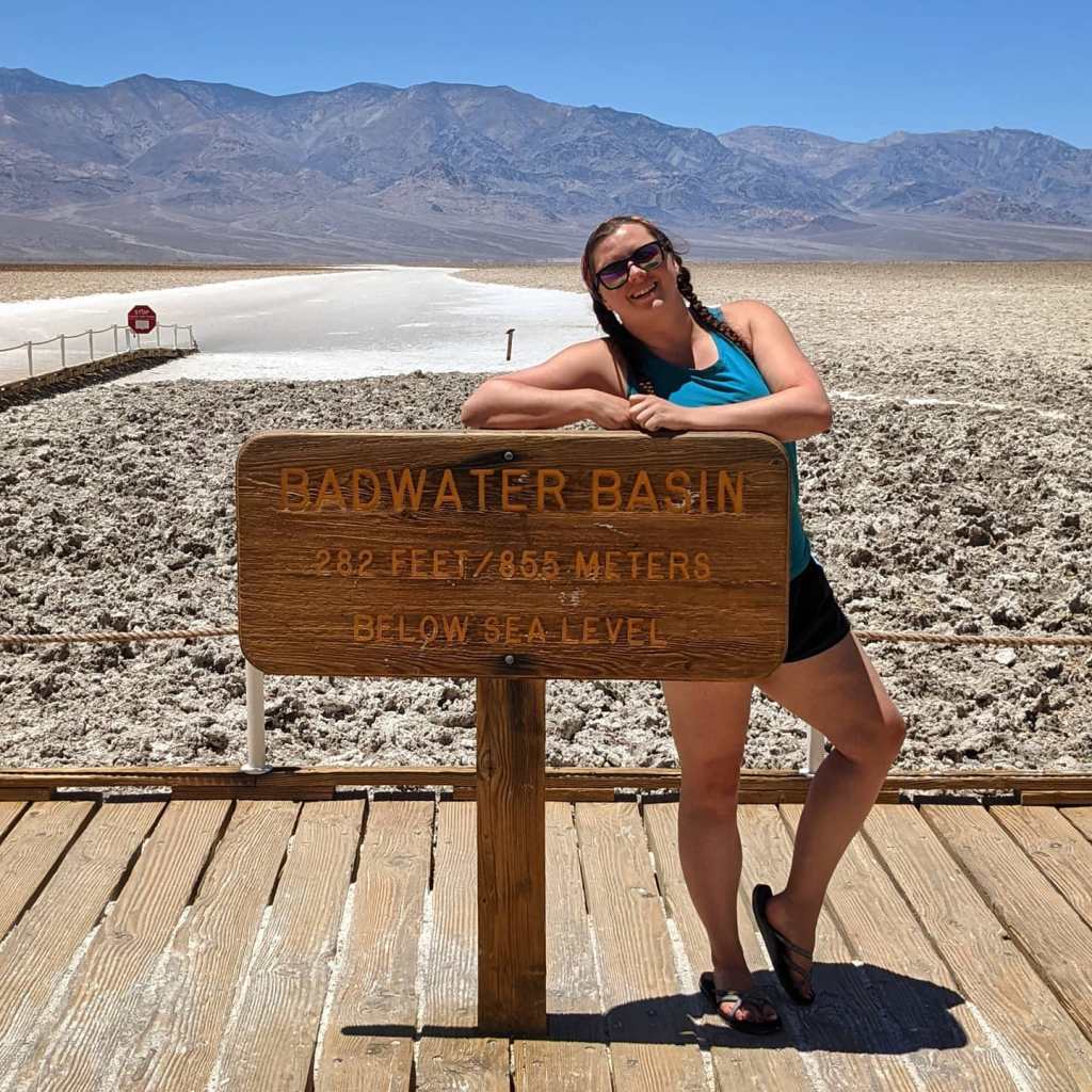
Coming from Utah we had a few different options for driving to Whitney Portal. The fastest reccommended route went through central Nevada where there is essentially nothing. However for just about an extra hour of detour, by taking I-15 south to Vegas, we could drive through Death Valley on our way and hit up Badwater Basin, which is what we decided to do!
Initially, I personally had ZERO desire to ever visit Death Valley. It’s notoriously hot, and I don’t do well with heat. But with it literally being on the way, and having the opportunity to hit the lowest point and then the highest point, we couldn’t pass it up. We lucked a little bit with the weather as it was incredibly windy and cooler than usual (by cooler meaning it was 102 degrees instead of 122). I was also pleasantly surprised at what all the park had to offer. I was very much expecting just a desolate valley wasteland and I had no idea there were petrified sand dunes, and incredibly textured prominent peaks that looked like they were out of Star Wars until we got there. We whitnessed a couple dust devils, and of course took a pit stop to the low salt flats of Badwater Basin, the lowest point in the US at -282 feet below sea level.
A quick note if you decide to go through this park ever (especially in the summer): have lots of water in the car, make sure your tank is full, your antifreeze is full, and your tires are good! It is the largest national park in the country and there is little to no cell service in the park and would be a terrible place to break down.
WHITNEY BOUND
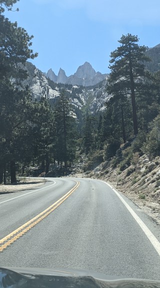
After our adventure in the desert, we made the remaining 2 1/2 hour drive to Whitney Portal, located just outside the town of Lone Pine. Car camping at the trailhead is not allowed. There are about 25 walk-in campsites located at the portal. A little further down the road is Lone Pine campground. Those spaces are reservable and is a cool place to camp with all the rocks. Whitney Portal is in active black bear territory. You cannot leave food or anything smelly in your car, bears have and will break into cars. There are bear boxes in the parking lot to store your food while you hike which is really conveinient. There is a little gift shop and grill at the portal it seems like their hours vary just a little from season to season. Currently they are open until 6:30pm so if you return from your hike before then, definitely reward yourself with a burger! It will taste so good after a long day on the mountain.
We started our climb at midnight. When we initially arrived at the portal the afternoon prior, it was insanely windy. Gusts at the summit were topping 80-90mph. People coming down that evening looked absolutely hammered and defeated. The winds were forecasted to die down overnight and by sunrise be reduced to sustained winds of maybe 10-15mph rather than 45-50. We prepared for wind and cold, however we severely underestimated just how cold and how windy…

There are several landmarks that can help break up this long hike, especially if you opt to do the climb in a single day like we did. Something important to note as well is that AllTrails is off by a couple miles. We used Strava to track and found it was a grand total of 23.4 miles round trip. Checking several other reports as well as just monitoring our pace with experience, I think our Strava track was more accurate. The first landmark was the log bridges and Lone Pine Lake about 3 miles in. We were moving at a solid pace and arrive at the sign for the lake about an hour and a half into our hike. About a half hour and a mile later we arrived at Outpost camp area, and within another half hour and just shy of another mile we made it to Mirror Lake putting us just shy of 5 miles in a little less than 2 1/2 hours.

The next 2 miles were more brutal than I expexted. I thought we only had a mile left to Trail camp since I was going off inaccurate information, but in reality, we had 2 miles, and they were long and awkward. I dub this section the “Whitney Stairmaster 5000”. The trail steepens and becomes incredibly rocky. There are a couple landmarks such as coming up through treeline, “the meadow”, and “the traverse”, but it was so dark we couldn’t see anything anyway, and we were battling brutal winds. The higher we got, the windier and colder it got. This section also slowed us down. It took over an hour and a half to get through this section. Most of the trail was straight forward, but there were a few spots that tripped us up in the dark and we would have to stop and figure out where to go.
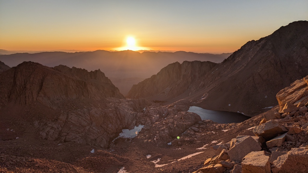
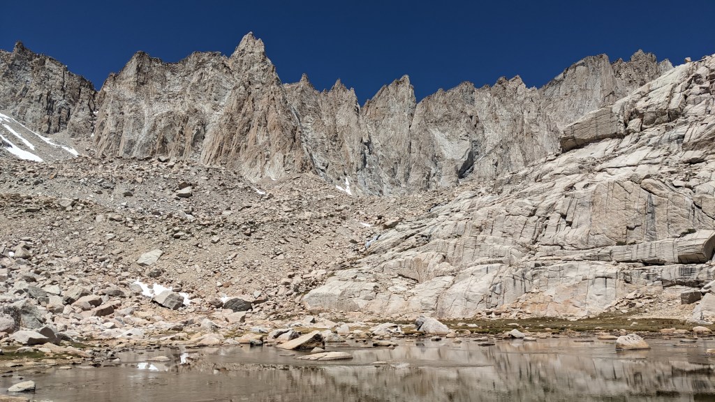
Finally, we make it to Trail camp at 12,000′ and nearly 7 miles in. It’s 4am and the winds were so cold, Trail Camp Tarn literally re-froze overnight. Our camelbacks were frozen and our waterbottles were becoming slushies. We took a pause under a rock trying to escape the unbearable frigid winds and debating our next move. We decided to keep going hoping that the 99 switchbacks would be somewhat sheltered from the wind because of the apparent direction it was coming from, and that the sunrise would bring some warmth and calm the winds as forecasted. We slowly made our way up the switchbacks, finding that once we were up several of them, they were slightly sheltered and gave us a bit of relief. We were at about 13,000′ come sunrise at about 5:30 and it was absolutely stunning. It really gave us a second wind to help us push on.
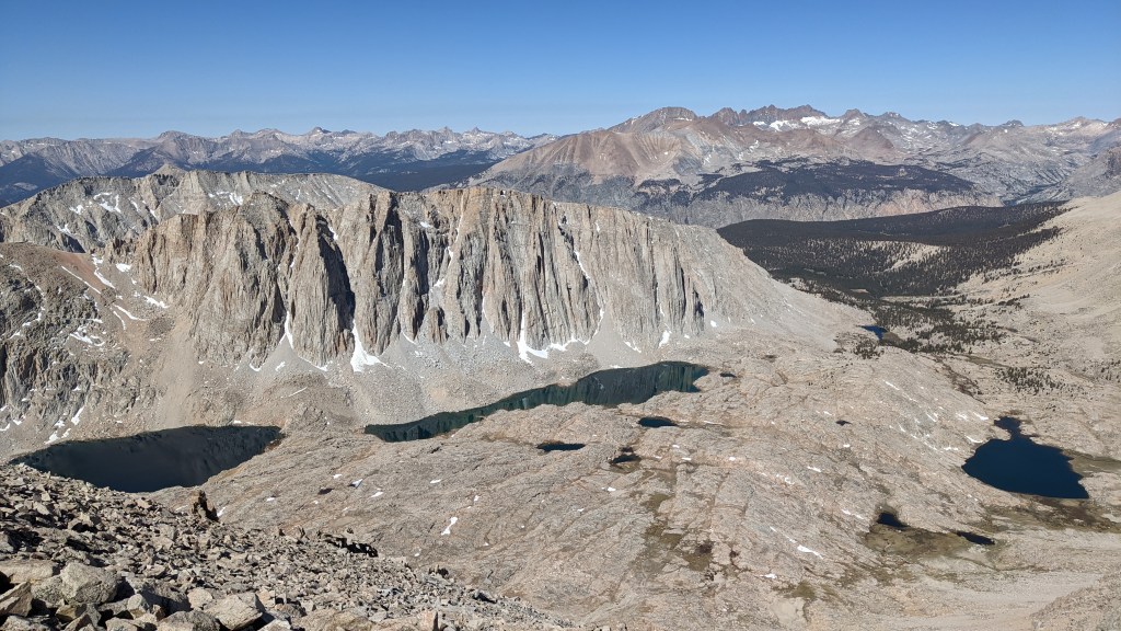
We made it to Trail Crest at 13,650′ and it was immedately back into the cold frigid winds as we transitioned to the shady back side of the mountain. Despite being freezing, the views of the west side with Guitar Lake were stunning. The trail drops down about 200′ (which was a bitch to climb back up later) to meet up with the junction of the John Muir Trail. We check the time at the junction to see it is 6:40am and we have just shy of 2 miles left to go. While most of the backside is fairly flat, its rocky, and uneven talus at high altitude making it slow, and for us, almost painful in those frigid winds. The final 500′ or so were probably the most brutal for us in the winds the entire climb. We were completely exposed to the full force of the wind, no more big rocks to hide under, and at this point it was just telling ourselves “we can warm up at the summit shelter and get out of the wind” that kept us moving.
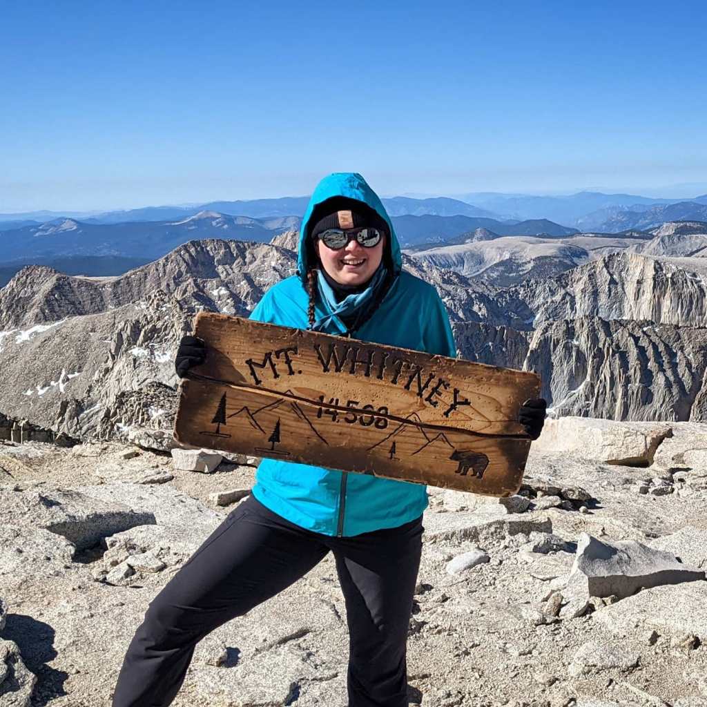
We summited at 8:30am. When I checked the weather later I found out we still had 25mph sustained winds and gusts up to 40 on the summit at that time, making our windchill -4 degrees (literally a 106 degree difference from the day before). We didn’t stay long. We snapped some very quick summit photos, hiding on the leeward side of the shelter in between shots. We headed down at 9am and pretty much didn’t stop until we reached Trail Camp again at about 11am.
Here at the tarn, we took our first real break after 11 straight hours in the wind, only really stopping to catch our breath (and take summit photos). We hung out at the tarn for about an hour; enjoyed the warmth of the sun, ate some lunch, stripped some layers, took some photos, and finally took in what we just battled through, celebrating our crazy successful summit.
From here it was just a long 3 hours back to the car, but at least we got to see what we missed on the way up. Stumbling over rocks on the stairmaster 5000, We finally got to take in the views of the rocky terrain, see Mirror Lake, check out the Waterfall at Outpost Camp (that I didn’t even know was there on the way up), and see Lone Pine lake. The longest section was definitely those last 3 miles. While it only took an hour…. it was a mentally LONG hour to push through. It just never ends and you want to be done. With about a mile left I found I hit a spot with cell service on the traill and briefly called my dad and my husband to let them know I was almost down and to story tell of the crazy windy adventure we had.
Not including our summit break and hour long break at Trail Camp, it took us 13 1/2 hours total, though we spent about 15 hours on the mountain. About 8 1/2 hours to summit, 5 hours down which is about what I predicted. I was guestimating it would take us 8 to summit but those winds man… They will mess with your head and make you question your life choices.
As much as I would love to say this is a one and done mountain for me, I know it probably isn’t. I just hope next time there is less wind! XD

Looks like a great time! Going back next year.
LikeLike